The Ring of Fire
Plate edges, volcanoes and large earthquakes around the Pacific: where the Earth moved since 2024, how often large earthquakes happen, the 15 largest since 1900, and what a typical year looks like.
Preview This story is not published yet. Atlas checks every number against its source before it goes public. It was put together by hand for design and research; Atlas cannot yet make a story like this from a question.
- Volcanoes in NCEI's list1,609192 with a significant eruption since 1900
- Magnitude 6 or more, 2025145earthquakes worldwide (USGS)
- Magnitude 6 or more, 2026 so far111to 16 Oct 2026
Step 1: Where it is now
Where the Earth moves now
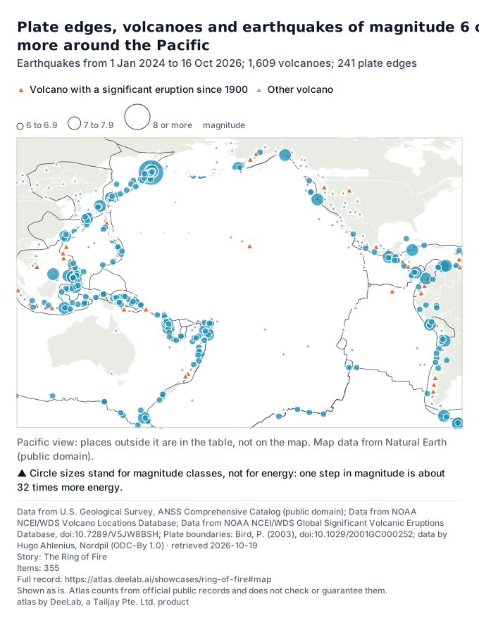
The Ring of Fire is the chain of plate edges, volcanoes and earthquakes around the Pacific Ocean. Of the 1,609 volcanoes in NOAA NCEI's list, 192 had an eruption that NCEI lists as significant since 1900 (orange triangles).
Since 1 Jan 2024 there were 355 earthquakes of magnitude 6 or more worldwide; the largest of these 355 was magnitude 8.8, 2025 Kamchatka Peninsula, Russia Earthquake (29 Jul 2025).

Show the table (355 rows)
| Date | Magnitude | Place (USGS) |
|---|---|---|
| 2026-10-16 | 6.9 | 76 km NE of Ozernovskiy, Russia |
| 2026-10-13 | 6.0 | 126 km S of Kokopo, Papua New Guinea |
| 2026-10-13 | 6.8 | central Mid-Atlantic Ridge |
| 2026-10-13 | 6.7 | central Mid-Atlantic Ridge |
| 2026-10-12 | 6.1 | 17 km W of Río Grande, Panama |
| 2026-10-11 | 6.2 | 79 km SSE of Panguna, Papua New Guinea |
| 2026-10-10 | 6.0 | 7 km N of La Tronosa, Panama |
| 2026-10-09 | 6.6 | 12 km W of Río Grande, Panama |
| 2026-10-09 | 7.7 | 12 km WSW of Pitaloza Arriba, Panama |
| 2026-10-08 | 6.3 | 102 km NE of Norsup, Vanuatu |
| 2026-09-25 | 6.7 | 74 km ENE of Tadine, New Caledonia |
| 2026-09-20 | 6.4 | 50 km NNE of Kainantu, Papua New Guinea |
| 2026-09-17 | 6.5 | 177 km W of Nikolski, Alaska |
| 2026-09-11 | 6.5 | 121 km NNE of Teluknaga, Indonesia |
| 2026-09-03 | 6.3 | 92 km SSW of Nikolski, Alaska |
| 2026-09-02 | 6.2 | South Sandwich Islands region |
| 2026-08-24 | 6.0 | 211 km NNE of Lospalos, Timor Leste |
| 2026-08-23 | 6.0 | 32 km SSW of Honchō, Japan |
| 2026-08-22 | 6.2 | Scotia Sea |
| 2026-08-20 | 6.7 | 35 km ENE of Tambo, Peru |
| 2026-08-16 | 6.1 | 63 km NNE of Port-Olry, Vanuatu |
| 2026-08-15 | 6.9 | 9 km WNW of Pematangsiantar, Indonesia |
| 2026-08-14 | 6.1 | 62 km N of Ende, Indonesia |
| 2026-08-14 | 7.8 | 66 km NNW of Ende, Indonesia |
| 2026-08-12 | 6.0 | South Sandwich Islands region |
| 2026-08-10 | 7.4 | 4 km SSW of San José del Palmar, Colombia |
| 2026-08-05 | 6.3 | south of the Kermadec Islands |
| 2026-08-05 | 6.3 | 32 km SW of Sarangani, Philippines |
| 2026-07-28 | 6.8 | The 2026 Kumamoto Region, Japan Earthquake |
| 2026-07-24 | 6.0 | 63 km WSW of Sola, Vanuatu |
| 2026-07-17 | 6.4 | 96 km SW of Puerto Madero, Mexico |
| 2026-07-17 | 7.3 | 60 km WSW of Puerto Madero, Mexico |
| 2026-07-14 | 6.2 | 33 km WSW of Sarangani, Philippines |
| 2026-07-13 | 6.3 | southeast of the Loyalty Islands |
| 2026-07-13 | 6.4 | 196 km SE of Lorengau, Papua New Guinea |
| 2026-07-11 | 6.4 | South Sandwich Islands region |
| 2026-07-03 | 6.1 | 147 km NNE of Hirara, Japan |
| 2026-07-03 | 6.2 | 61 km W of Tobelo, Indonesia |
| 2026-07-01 | 6.0 | 54 km ENE of Noda, Japan |
| 2026-06-30 | 6.0 | 75 km SSW of El Progreso, Mexico |
| 2026-06-27 | 6.1 | 47 km S of Jurm, Afghanistan |
| 2026-06-26 | 6.5 | 44 km SW of Balangonan, Philippines |
| 2026-06-24 | 6.9 | 35 km ENE of Noda, Japan |
| 2026-06-24 | 7.5 | 20 km W of Catia La Mar, Venezuela |
| 2026-06-24 | 7.2 | 20 km E of San Felipe, Venezuela |
| 2026-06-19 | 6.6 | 141 km ESE of Petropavlovsk-Kamchatsky, Russia |
| 2026-06-17 | 6.6 | central Mid-Atlantic Ridge |
| 2026-06-16 | 6.3 | 262 km SSE of Dunhuang, China |
| 2026-06-16 | 6.7 | 40 km SE of Palu, Indonesia |
| 2026-06-15 | 6.2 | 76 km ESE of Pondaguitan, Philippines |
| 2026-06-10 | 6.0 | Auckland Islands, New Zealand region |
| 2026-06-08 | 6.1 | 99 km WNW of Mantua, Cuba |
| 2026-06-08 | 6.5 | 18 km SW of Balangonan, Philippines |
| 2026-06-07 | 6.0 | 5 km SSW of Pangyan, Philippines |
| 2026-06-07 | 6.1 | 19 km SW of Balangonan, Philippines |
| 2026-06-07 | 7.8 | 25 km SW of Kablalan, Philippines |
| 2026-06-07 | 6.0 | 111 km SE of Severo-Kuril’sk, Russia |
| 2026-06-01 | 6.2 | 23 km WSW of San Lucido, Italy |
| 2026-05-31 | 6.0 | 33 km NW of Valparaíso, Chile |
| 2026-05-27 | 6.0 | western Indian-Antarctic Ridge |
| 2026-05-27 | 6.0 | western Indian-Antarctic Ridge |
| 2026-05-25 | 6.9 | 34 km ENE of Calama, Chile |
| 2026-05-20 | 6.6 | southern East Pacific Rise |
| 2026-05-16 | 6.0 | 61 km ESE of Codrington, Antigua and Barbuda |
| 2026-05-15 | 6.7 | 41 km ESE of Ōfunato, Japan |
| 2026-05-14 | 6.2 | 268 km WSW of Tual, Indonesia |
| 2026-05-09 | 6.1 | Rat Islands, Aleutian Islands, Alaska |
| 2026-05-04 | 6.0 | 10 km WSW of Nena, Philippines |
| 2026-04-20 | 6.0 | 100 km E of Miyako, Japan |
| 2026-04-20 | 7.4 | 102 km ENE of Miyako, Japan |
| 2026-04-19 | 6.1 | 88 km NNE of Hihifo, Tonga |
| 2026-04-16 | 6.0 | south of the Kermadec Islands |
| 2026-04-04 | 6.0 | 95 km SE of Sarangani, Philippines |
| 2026-04-02 | 6.3 | 109 km WNW of Ternate, Indonesia |
| 2026-04-01 | 7.4 | 129 km ESE of Bitung, Indonesia |
| 2026-04-01 | 6.0 | 19 km SE of Picota, Peru |
| 2026-03-30 | 7.3 | 51 km ENE of Luganville, Vanuatu |
| 2026-03-26 | 6.5 | 123 km E of Yamada, Japan |
| 2026-03-24 | 7.5 | 158 km W of Neiafu, Tonga |
| 2026-03-22 | 6.3 | 140 km ENE of Hihifo, Tonga |
| 2026-03-22 | 6.2 | 148 km ENE of Hihifo, Tonga |
| 2026-03-22 | 6.2 | 121 km NE of Hihifo, Tonga |
| 2026-03-21 | 6.6 | northern Mid-Atlantic Ridge |
| 2026-03-20 | 6.1 | 98 km WNW of Isangel, Vanuatu |
| 2026-03-20 | 6.5 | South Shetland Islands |
| 2026-03-13 | 6.2 | 71 km W of Vallenar, Chile |
| 2026-03-09 | 6.0 | 16 km SSE of Sant'Angelo, Italy |
| 2026-03-08 | 6.0 | 7 km WSW of Hihifo, Tonga |
| 2026-03-06 | 6.2 | 170 km SE of Kirakira, Solomon Islands |
| 2026-03-04 | 6.4 | 223 km ESE of Attu Station, Alaska |
| 2026-03-03 | 6.2 | 62 km SE of Sinabang, Indonesia |
| 2026-03-02 | 6.0 | Volcano Islands, Japan region |
| 2026-03-01 | 6.3 | Fiji region |
| 2026-02-23 | 6.0 | 96 km SW of Nikolski, Alaska |
| 2026-02-22 | 7.1 | 57 km NNW of Kota Belud, Malaysia |
| 2026-02-22 | 6.0 | south of the Fiji Islands |
| 2026-02-16 | 6.0 | 87 km ESE of Ozernovskiy, Russia |
| 2026-02-14 | 6.4 | 48 km W of Port-Olry, Vanuatu |
| 2026-02-12 | 6.1 | 28 km SW of Ovalle, Chile |
| 2026-02-10 | 6.2 | Fiji region |
| 2026-02-04 | 6.1 | Kermadec Islands, New Zealand |
| 2026-01-29 | 6.0 | South Sandwich Islands region |
| 2026-01-22 | 6.2 | 127 km S of Vilyuchinsk, Russia |
| 2026-01-21 | 6.1 | Volcano Islands, Japan region |
| 2026-01-19 | 6.0 | 277 km ESE of Tadine, New Caledonia |
| 2026-01-16 | 6.0 | off the coast of Oregon |
| 2026-01-13 | 6.2 | 135 km SE of Kuril’sk, Russia |
| 2026-01-10 | 6.4 | 247 km SE of Sarangani, Philippines |
| 2026-01-07 | 6.4 | 35 km E of Santiago, Philippines |
| 2026-01-02 | 6.5 | 0 km W of San Marcos, Mexico |
| 2026-01-01 | 6.0 | southeast Indian Ridge |
| 2025-12-31 | 6.0 | 96 km E of Noda, Japan |
| 2025-12-28 | 6.2 | 43 km W of Puerto Santa, Peru |
| 2025-12-27 | 6.6 | 29 km ESE of Yilan, Taiwan |
| 2025-12-24 | 6.0 | 2025 Taitung, Taiwan Earthquake |
| 2025-12-22 | 6.5 | 45 km NNE of Goroka, Papua New Guinea |
| 2025-12-12 | 6.7 | 117 km NE of Kuji, Japan |
| 2025-12-08 | 6.6 | 129 km S of Honchō, Japan |
| 2025-12-08 | 6.0 | 127 km S of Honchō, Japan |
| 2025-12-08 | 7.6 | 2025 Aomori Prefecture, Japan Earthquake |
| 2025-12-06 | 7.0 | 2025 Hubbard Glacier Earthquake |
| 2025-11-27 | 6.0 | 12 km WNW of Susitna, Alaska |
| 2025-11-27 | 6.4 | 54 km WNW of Sinabang, Indonesia |
| 2025-11-10 | 6.0 | 129 km E of Yamada, Japan |
| 2025-11-09 | 6.4 | 117 km E of Yamada, Japan |
| 2025-11-09 | 6.8 | 122 km E of Yamada, Japan |
| 2025-11-04 | 6.0 | 149 km SE of Petropavlovsk-Kamchatsky, Russia |
| 2025-11-04 | 6.0 | 191 km WSW of Merizo Village, Guam |
| 2025-11-03 | 6.1 | 142 km SE of Petropavlovsk-Kamchatsky, Russia |
| 2025-11-02 | 6.2 | 30 km SE of Mazār-e Sharīf, Afghanistan |
| 2025-10-28 | 6.4 | Banda Sea |
| 2025-10-27 | 6.0 | 7 km SE of Sındırgı, Turkey |
| 2025-10-27 | 6.5 | 164 km E of Beauséjour, Guadeloupe |
| 2025-10-26 | 6.2 | 57 km NW of Pante Makasar, Timor Leste |
| 2025-10-25 | 6.0 | 194 km SSE of Lata, Solomon Islands |
| 2025-10-16 | 6.0 | 3 km N of Union, Philippines |
| 2025-10-16 | 6.4 | 192 km WNW of Abepura, Indonesia |
| 2025-10-16 | 6.3 | Drake Passage |
| 2025-10-11 | 6.0 | 3 km ESE of Bacolod, Philippines |
| 2025-10-10 | 7.6 | Drake Passage |
| 2025-10-10 | 6.7 | 12 km SE of Santiago, Philippines |
| 2025-10-10 | 6.3 | 139 km SE of Lorengau, Papua New Guinea |
| 2025-10-10 | 7.4 | 12 km E of Santiago, Philippines |
| 2025-10-09 | 6.1 | 121 km E of Ozernovskiy, Russia |
| 2025-10-07 | 6.6 | 17 km W of Lae, Papua New Guinea |
| 2025-10-03 | 6.1 | 177 km SE of Vilyuchinsk, Russia |
| 2025-09-30 | 6.0 | 31 km ESE of Kalianget, Indonesia |
| 2025-09-30 | 6.9 | 8 km ESE of Calape, Philippines |
| 2025-09-25 | 6.3 | 25 km ENE of Mene Grande, Venezuela |
| 2025-09-24 | 6.2 | 5 km ENE of Mene Grande, Venezuela |
| 2025-09-19 | 6.0 | 98 km ESE of Ozernovskiy, Russia |
| 2025-09-18 | 7.8 | 140 km E of Petropavlovsk-Kamchatsky, Russia |
| 2025-09-18 | 6.0 | 26 km S of Nabire, Indonesia |
| 2025-09-16 | 6.0 | 208 km SE of Kokopo, Papua New Guinea |
| 2025-09-15 | 6.0 | 144 km ESE of Petropavlovsk-Kamchatsky, Russia |
| 2025-09-13 | 7.4 | 105 km E of Petropavlovsk-Kamchatsky, Russia |
| 2025-09-08 | 6.4 | Vanuatu region |
| 2025-08-31 | 6.0 | 35 km WSW of Asadābād, Afghanistan |
| 2025-08-27 | 6.0 | 92 km E of Severo-Kuril’sk, Russia |
| 2025-08-25 | 6.1 | east of the Kuril Islands |
| 2025-08-23 | 6.0 | 88 km SW of Acajutla, El Salvador |
| 2025-08-22 | 7.5 | 2025 Southern Drake Passage Earthquake |
| 2025-08-14 | 6.3 | 115 km SSE of Lata, Solomon Islands |
| 2025-08-12 | 6.3 | 195 km WNW of Abepura, Indonesia |
| 2025-08-10 | 6.1 | 10 km WSW of Bigadiç, Turkey |
| 2025-08-09 | 6.0 | 265 km ESE of Severo-Kuril’sk, Russia |
| 2025-08-04 | 6.2 | 202 km S of Severo-Kuril’sk, Russia |
| 2025-08-03 | 6.8 | 123 km E of Severo-Kuril’sk, Russia |
| 2025-08-03 | 6.3 | Pacific-Antarctic Ridge |
| 2025-08-02 | 6.0 | 165 km SSE of Vilyuchinsk, Russia |
| 2025-08-01 | 6.1 | 215 km ESE of Severo-Kuril’sk, Russia |
| 2025-07-31 | 6.2 | 222 km SE of Severo-Kuril’sk, Russia |
| 2025-07-30 | 6.0 | 138 km SE of Severo-Kuril’sk, Russia |
| 2025-07-30 | 6.1 | 183 km SE of Vilyuchinsk, Russia |
| 2025-07-30 | 6.2 | 126 km SE of Vilyuchinsk, Russia |
| 2025-07-30 | 6.9 | 125 km SE of Petropavlovsk-Kamchatsky, Russia |
| 2025-07-29 | 6.0 | 165 km SSE of Vilyuchinsk, Russia |
| 2025-07-29 | 6.0 | 124 km ENE of Ozernovskiy, Russia |
| 2025-07-29 | 6.1 | 78 km SE of Petropavlovsk-Kamchatsky, Russia |
| 2025-07-29 | 6.3 | 94 km SE of Petropavlovsk-Kamchatsky, Russia |
| 2025-07-29 | 8.8 | 2025 Kamchatka Peninsula, Russia Earthquake |
| 2025-07-29 | 6.6 | south of the Fiji Islands |
| 2025-07-28 | 7.0 | Macquarie Island region |
| 2025-07-28 | 6.4 | 264 km WNW of Sabang, Indonesia |
| 2025-07-26 | 6.2 | Macquarie Island region |
| 2025-07-25 | 6.2 | west of Macquarie Island |
| 2025-07-24 | 6.6 | 187 km SSE of Mata-Utu, Wallis and Futuna |
| 2025-07-24 | 6.0 | 163 km E of Petropavlovsk-Kamchatsky, Russia |
| 2025-07-23 | 6.3 | 109 km W of Gorontalo, Indonesia |
| 2025-07-22 | 6.0 | 154 km ESE of Petropavlovsk-Kamchatsky, Russia |
| 2025-07-20 | 6.2 | 91 km SSE of Sand Point, Alaska |
| 2025-07-20 | 6.5 | 143 km E of Petropavlovsk-Kamchatsky, Russia |
| 2025-07-20 | 6.6 | 153 km ESE of Petropavlovsk-Kamchatsky, Russia |
| 2025-07-20 | 7.4 | 2025 Eastern Kamchatka, Russia Earthquake |
| 2025-07-20 | 6.6 | 134 km E of Petropavlovsk-Kamchatsky, Russia |
| 2025-07-16 | 7.3 | 2025 Sand Point, Alaska Earthquake |
| 2025-07-14 | 6.2 | 206 km S of Burica, Panama |
| 2025-07-14 | 6.7 | 180 km WSW of Tual, Indonesia |
| 2025-07-07 | 6.2 | 213 km WSW of Riverton, New Zealand |
| 2025-06-28 | 6.6 | Scotia Sea |
| 2025-06-27 | 6.0 | 65 km E of Sarangani, Philippines |
| 2025-06-25 | 6.2 | southern Mid-Atlantic Ridge |
| 2025-06-24 | 6.2 | east of the Philippine Islands |
| 2025-06-21 | 6.0 | 82 km SE of Nemuro, Japan |
| 2025-06-13 | 6.0 | Kuril Islands |
| 2025-06-08 | 6.3 | 15 km NE of Paratebueno, Colombia |
| 2025-06-07 | 6.2 | western Indian-Antarctic Ridge |
| 2025-06-06 | 6.4 | 45 km SW of Diego de Almagro, Chile |
| 2025-05-31 | 6.2 | Kermadec Islands region |
| 2025-05-31 | 6.0 | Kermadec Islands region |
| 2025-05-31 | 6.1 | Kermadec Islands region |
| 2025-05-31 | 6.0 | 78 km S of Kushiro, Japan |
| 2025-05-30 | 6.2 | southwest of Africa |
| 2025-05-25 | 6.0 | 187 km SSW of ‘Ohonua, Tonga |
| 2025-05-23 | 6.1 | west of Macquarie Island |
| 2025-05-22 | 6.2 | 66 km SE of Emporeío, Greece |
| 2025-05-20 | 6.5 | 89 km ENE of Angoram, Papua New Guinea |
| 2025-05-14 | 6.4 | 142 km W of Neiafu, Tonga |
| 2025-05-13 | 6.0 | 20 km SSE of Fry, Greece |
| 2025-05-05 | 6.0 | southern East Pacific Rise |
| 2025-05-02 | 6.4 | 289 km SSE of Ushuaia, Argentina |
| 2025-05-02 | 7.4 | 2025 Drake Passage Earthquake |
| 2025-04-29 | 6.8 | Macquarie Island region |
| 2025-04-29 | 6.2 | 285 km SW of Bluff, New Zealand |
| 2025-04-25 | 6.3 | 19 km NE of Esmeraldas, Ecuador |
| 2025-04-23 | 6.2 | 24 km SE of Marmara Ereğlisi, Turkey |
| 2025-04-22 | 6.2 | 271 km SE of Pondaguitan, Philippines |
| 2025-04-16 | 6.6 | southeast Indian Ridge |
| 2025-04-13 | 6.5 | south of the Fiji Islands |
| 2025-04-12 | 6.1 | 104 km ESE of Kokopo, Papua New Guinea |
| 2025-04-04 | 6.9 | 184 km ESE of Kimbe, Papua New Guinea |
| 2025-04-03 | 6.9 | Reykjanes Ridge |
| 2025-04-02 | 6.1 | 56 km ENE of Nishinoomote, Japan |
| 2025-04-02 | 6.3 | Pacific-Antarctic Ridge |
| 2025-03-30 | 6.2 | 72 km SSE of Pangai, Tonga |
| 2025-03-30 | 7.0 | 61 km SSE of Pangai, Tonga |
| 2025-03-28 | 6.6 | central Mid-Atlantic Ridge |
| 2025-03-28 | 6.7 | Burma (Myanmar) |
| 2025-03-28 | 7.7 | 2025 Mandalay, Burma (Myanmar) Earthquake |
| 2025-03-28 | 6.1 | central Mid-Atlantic Ridge |
| 2025-03-25 | 6.7 | 170 km WSW of Riverton, New Zealand |
| 2025-03-21 | 6.2 | 88 km SSE of Adak, Alaska |
| 2025-03-21 | 6.2 | 124 km SSE of Burica, Panama |
| 2025-03-12 | 6.0 | Nicobar Islands, India region |
| 2025-03-10 | 6.5 | 34 km NE of Olonkinbyen, Svalbard and Jan Mayen |
| 2025-03-06 | 6.0 | 98 km S of Calama, Chile |
| 2025-02-25 | 6.1 | 45 km E of Modisi, Indonesia |
| 2025-02-23 | 6.0 | 85 km SE of Lata, Solomon Islands |
| 2025-02-08 | 7.6 | 210 km SSW of George Town, Cayman Islands |
| 2025-01-20 | 6.0 | 10 km NE of Yujing, Taiwan |
| 2025-01-13 | 6.8 | 15 km SE of Miyazaki, Japan |
| 2025-01-12 | 6.2 | 18 km SE of Aquila, Mexico |
| 2025-01-07 | 7.1 | 2025 Southern Tibetan Plateau Earthquake |
| 2025-01-05 | 6.2 | 56 km SSE of La Libertad, El Salvador |
| 2025-01-02 | 6.1 | 84 km NNW of Calama, Chile |
| 2025-01-01 | 6.1 | South Sandwich Islands region |
| 2024-12-27 | 6.8 | Kuril Islands |
| 2024-12-21 | 6.1 | 33 km W of Port-Vila, Vanuatu |
| 2024-12-17 | 7.3 | 24 km WNW of Port-Vila, Vanuatu |
| 2024-12-13 | 6.4 | 56 km ESE of Molina, Chile |
| 2024-12-09 | 6.1 | 126 km SSW of Adak, Alaska |
| 2024-12-09 | 6.3 | 104 km SSW of Adak, Alaska |
| 2024-12-08 | 6.3 | 108 km SSW of Adak, Alaska |
| 2024-12-08 | 6.0 | Kuril Islands |
| 2024-12-05 | 7.0 | 2024 Offshore Cape Mendocino, California Earthquake |
| 2024-11-26 | 6.1 | 38 km WNW of Hakui, Japan |
| 2024-11-17 | 6.1 | 156 km SSE of Koshima, Japan |
| 2024-11-15 | 6.6 | 122 km ESE of Kokopo, Papua New Guinea |
| 2024-11-10 | 6.8 | 42 km SSW of Bartolomé Masó, Cuba |
| 2024-11-08 | 6.3 | 239 km WNW of Cochrane, Chile |
| 2024-10-30 | 6.0 | 267 km W of Bandon, Oregon |
| 2024-10-30 | 6.0 | 126 km N of Kimbe, Papua New Guinea |
| 2024-10-23 | 6.2 | 146 km SSW of Severo-Kuril’sk, Russia |
| 2024-10-16 | 6.0 | 19 km W of Doğanyol, Turkey |
| 2024-10-12 | 6.2 | 40 km WNW of Tamarindo, Costa Rica |
| 2024-10-01 | 6.6 | 125 km SE of Neiafu, Tonga |
| 2024-10-01 | 6.1 | 260 km ESE of Baubau, Indonesia |
| 2024-09-26 | 6.3 | Mauritius - Reunion region |
| 2024-09-23 | 6.0 | 67 km SSW of Gorontalo, Indonesia |
| 2024-09-21 | 6.0 | 95 km NNW of Villa General Roca, Argentina |
| 2024-09-16 | 6.3 | 266 km NE of Saipan, Northern Mariana Islands |
| 2024-09-15 | 6.5 | 271 km WNW of Port McNeill, Canada |
| 2024-09-11 | 6.3 | 168 km SW of Lorengau, Papua New Guinea |
| 2024-09-05 | 6.2 | 59 km NNE of Angoram, Papua New Guinea |
| 2024-09-01 | 6.4 | 56 km S of Panguna, Papua New Guinea |
| 2024-08-30 | 6.0 | 117 km E of Petropavlovsk-Kamchatsky, Russia |
| 2024-08-28 | 6.1 | 56 km SSW of La Libertad, El Salvador |
| 2024-08-25 | 6.0 | 65 km W of Pangai, Tonga |
| 2024-08-25 | 6.9 | 75 km W of Pangai, Tonga |
| 2024-08-17 | 7.0 | 102 km E of Petropavlovsk-Kamchatsky, Russia |
| 2024-08-15 | 6.1 | 30 km SSE of Hualien City, Taiwan |
| 2024-08-10 | 6.5 | 151 km E of Dolinsk, Russia |
| 2024-08-08 | 7.1 | 2024 Hyuganada Sea, Japan Earthquake |
| 2024-08-03 | 6.3 | 44 km E of Barcelona, Philippines |
| 2024-08-02 | 6.8 | 20 km E of Barcelona, Philippines |
| 2024-07-29 | 6.0 | 73 km SSE of Pangai, Tonga |
| 2024-07-22 | 6.1 | 99 km NE of Norsup, Vanuatu |
| 2024-07-21 | 6.2 | 6 km E of Jalapa, Guatemala |
| 2024-07-19 | 6.0 | 168 km SW of Nikolski, Alaska |
| 2024-07-19 | 7.4 | 41 km ESE of San Pedro de Atacama, Chile |
| 2024-07-11 | 6.4 | 209 km WSW of Tofino, Canada |
| 2024-07-11 | 7.1 | 106 km WSW of Sangay, Philippines |
| 2024-07-10 | 6.6 | south of Africa |
| 2024-07-07 | 6.2 | Bonin Islands, Japan region |
| 2024-06-29 | 6.1 | 34 km SW of Atiquipa, Peru |
| 2024-06-28 | 7.2 | 10 km WSW of Atiquipa, Peru |
| 2024-06-24 | 6.3 | 49 km NNE of Port-Olry, Vanuatu |
| 2024-06-23 | 6.0 | 20 km NE of Yaguaraparo, Venezuela |
| 2024-06-16 | 6.0 | 10 km SW of Atiquipa, Peru |
| 2024-06-16 | 6.0 | west of Macquarie Island |
| 2024-06-09 | 6.2 | Pacific-Antarctic Ridge |
| 2024-05-31 | 6.2 | Kermadec Islands region |
| 2024-05-31 | 6.2 | Prince Edward Islands region |
| 2024-05-26 | 6.6 | 70 km NW of Fangale’ounga, Tonga |
| 2024-05-25 | 6.3 | 83 km NW of Port-Vila, Vanuatu |
| 2024-05-19 | 6.0 | 169 km SW of Nikolski, Alaska |
| 2024-05-12 | 6.4 | 28 km WSW of Brisas Barra de Suchiate, Mexico |
| 2024-05-08 | 6.1 | 101 km ENE of Luganville, Vanuatu |
| 2024-05-05 | 6.1 | 154 km WSW of Fakfak, Indonesia |
| 2024-04-27 | 6.1 | 91 km S of Banjar, Indonesia |
| 2024-04-27 | 6.5 | Bonin Islands, Japan region |
| 2024-04-22 | 6.1 | 13 km SSW of Hualien City, Taiwan |
| 2024-04-22 | 6.1 | 29 km S of Hualien City, Taiwan |
| 2024-04-17 | 6.3 | 18 km W of Uwajima, Japan |
| 2024-04-14 | 6.5 | 111 km ESE of Kimbe, Papua New Guinea |
| 2024-04-09 | 6.4 | 150 km NW of Tobelo, Indonesia |
| 2024-04-05 | 6.8 | Maug Islands region, Northern Mariana Islands |
| 2024-04-04 | 6.1 | 77 km E of Minami-Sōma, Japan |
| 2024-04-03 | 6.4 | 15 km NNE of Hualien City, Taiwan |
| 2024-04-02 | 7.4 | 15 km S of Hualien City, Taiwan |
| 2024-04-02 | 6.2 | 137 km ENE of Saipan, Northern Mariana Islands |
| 2024-03-27 | 6.4 | Vanuatu region |
| 2024-03-23 | 6.9 | 36 km ENE of Ambunti, Papua New Guinea |
| 2024-03-22 | 6.4 | 110 km N of Paciran, Indonesia |
| 2024-03-14 | 6.2 | northern Mid-Atlantic Ridge |
| 2024-03-13 | 6.0 | 68 km ESE of Kimbe, Papua New Guinea |
| 2024-03-08 | 6.0 | 103 km SE of Pondaguitan, Philippines |
| 2024-03-05 | 6.1 | Macquarie Island region |
| 2024-03-03 | 6.8 | Macquarie Island region |
| 2024-02-23 | 6.3 | southern East Pacific Rise |
| 2024-02-14 | 6.0 | 171 km NNE of Colonia, Micronesia |
| 2024-02-12 | 6.1 | Volcano Islands, Japan region |
| 2024-02-09 | 6.1 | Kermadec Islands, New Zealand |
| 2024-01-28 | 6.5 | 70 km W of Tarauacá, Brazil |
| 2024-01-27 | 6.1 | 15 km W of Taxisco, Guatemala |
| 2024-01-23 | 6.3 | 39 km SW of Port-Vila, Vanuatu |
| 2024-01-22 | 7.0 | 128 km WNW of Aykol, China |
| 2024-01-20 | 6.2 | Southwest Indian Ridge |
| 2024-01-20 | 6.6 | 123 km NW of Tarauacá, Brazil |
| 2024-01-20 | 6.1 | Pagan region, Northern Mariana Islands |
| 2024-01-18 | 6.4 | 148 km NW of Fangale’ounga, Tonga |
| 2024-01-11 | 6.4 | 45 km SSW of Jurm, Afghanistan |
| 2024-01-08 | 6.7 | 93 km SE of Sarangani, Philippines |
| 2024-01-01 | 6.2 | 8 km SW of Anamizu, Japan |
| 2024-01-01 | 7.5 | 2024 Noto Peninsula, Japan Earthquake |
About this data
- Where it comes from
- U.S. Geological Survey: U.S. Geological Survey, ANSS Comprehensive Catalog (ComCat) · source
- NOAA National Centers for Environmental Information: NOAA NCEI/WDS Volcano Locations Database · source
- NOAA National Centers for Environmental Information: NOAA NCEI/WDS Global Significant Volcanic Eruptions Database · source
- Peter Bird (UCLA); GeoJSON by Hugo Ahlenius, Nordpil: PB2002 plate boundaries (Bird 2003), GeoJSON by Hugo Ahlenius, Nordpil · source
- Licence
- Data from U.S. Geological Survey, ANSS Comprehensive Catalog (public domain) (US public domain)
- Data from NOAA NCEI/WDS Volcano Locations Database (US government work, public domain)
- Data from NOAA NCEI/WDS Global Significant Volcanic Eruptions Database, doi:10.7289/V5JW8BSH (US government work, public domain; cite the DOI)
- Plate boundaries: Bird, P. (2003), doi:10.1029/2001GC000252; data by Hugo Ahlenius, Nordpil (ODC-By 1.0) (ODC-By 1.0 (conversion); both credits always (GL-5, D-044))
- Borders and coastlines: Natural Earth, 1:110 million scale, version 5.1.2, downloaded on 2026-10-18. Made with Natural Earth (public domain). Projection: Equal Earth. Borders follow Natural Earth's default view and are not a statement by Atlas.
- Retrieved
- 19 Oct 2026, 02:36 UTC; the owner last changed the file on 19 Oct 2026
- 19 Oct 2026, 02:36 UTC
- 19 Oct 2026, 02:36 UTC
- 19 Oct 2026, 02:36 UTC
- What Atlas did
- Drew the PB2002 plate edges (Bird 2003, GeoJSON by Hugo Ahlenius) as thin lines.
- Drew NOAA NCEI's volcano list as triangles; orange where NCEI lists a significant eruption since 1900.
- Drew every USGS earthquake of magnitude 6 or more since 1 Jan 2024 as a circle in three size classes.
- Weak points
- Circle sizes stand for magnitude classes, not for energy: one step in magnitude is about 32 times more energy.
Shown as is. Atlas counts from official public records and does not check or guarantee them.
Step 2: How it changed
How many large earthquakes a year
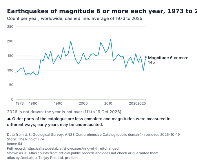
From 1973 to 2025 there were on average 138 earthquakes of magnitude 6 or more a year, from 83 in 1981 to 207 in 2011.
The first ten years (1973 to 1982) averaged 93 a year, the years since then 149. Since 1983, the yearly count goes up and down with no steady rise or fall (Mann-Kendall test, p = 0.47).
USGS notes that its catalogue holds more earthquakes in recent years as more seismic instruments record them, which is not the same as more earthquakes happening. Atlas makes no claim of a trend from these counts.

Show the table (54 rows)
| Year | Magnitude 6 or more (count) | 7 or more (count) | 8 or more (count) |
|---|---|---|---|
| 2026 | 111 | 12 | 0 |
| 2025 | 145 | 16 | 1 |
| 2024 | 99 | 10 | 0 |
| 2023 | 147 | 19 | 0 |
| 2022 | 127 | 11 | 0 |
| 2021 | 157 | 19 | 3 |
| 2020 | 121 | 9 | 0 |
| 2019 | 145 | 10 | 1 |
| 2018 | 134 | 17 | 1 |
| 2017 | 110 | 7 | 1 |
| 2016 | 147 | 16 | 0 |
| 2015 | 146 | 19 | 1 |
| 2014 | 155 | 12 | 1 |
| 2013 | 142 | 19 | 2 |
| 2012 | 133 | 16 | 2 |
| 2011 | 207 | 20 | 1 |
| 2010 | 174 | 24 | 1 |
| 2009 | 160 | 17 | 1 |
| 2008 | 179 | 12 | 0 |
| 2007 | 196 | 18 | 4 |
| 2006 | 153 | 11 | 2 |
| 2005 | 150 | 11 | 1 |
| 2004 | 157 | 16 | 2 |
| 2003 | 154 | 15 | 1 |
| 2002 | 139 | 13 | 0 |
| 2001 | 137 | 15 | 1 |
| 2000 | 160 | 15 | 1 |
| 1999 | 135 | 18 | 0 |
| 1998 | 121 | 12 | 1 |
| 1997 | 136 | 16 | 0 |
| 1996 | 164 | 15 | 1 |
| 1995 | 200 | 20 | 2 |
| 1994 | 158 | 13 | 2 |
| 1993 | 148 | 12 | 0 |
| 1992 | 178 | 13 | 0 |
| 1991 | 137 | 17 | 0 |
| 1990 | 153 | 18 | 0 |
| 1989 | 137 | 8 | 1 |
| 1988 | 122 | 11 | 0 |
| 1987 | 166 | 13 | 0 |
| 1986 | 138 | 11 | 1 |
| 1985 | 160 | 15 | 2 |
| 1984 | 133 | 14 | 0 |
| 1983 | 136 | 14 | 0 |
| 1982 | 87 | 8 | 0 |
| 1981 | 83 | 10 | 0 |
| 1980 | 95 | 6 | 0 |
| 1979 | 86 | 8 | 0 |
| 1978 | 90 | 12 | 0 |
| 1977 | 85 | 11 | 1 |
| 1976 | 109 | 14 | 1 |
| 1975 | 106 | 13 | 0 |
| 1974 | 97 | 11 | 0 |
| 1973 | 93 | 9 | 0 |
About this data
- Where it comes from
- U.S. Geological Survey: U.S. Geological Survey, ANSS Comprehensive Catalog (ComCat) · source
- Licence
- Data from U.S. Geological Survey, ANSS Comprehensive Catalog (public domain) (US public domain)
- Retrieved
- 19 Oct 2026, 02:36 UTC; the owner last changed the file on 19 Oct 2026
- What Atlas did
- Counted every event of type "earthquake" with magnitude 6 or more in the USGS ANSS Comprehensive Catalog, per calendar year (UTC).
- Tested the yearly counts for a steady rise or fall with the Mann-Kendall test (all years: p = 0.009; since 1983: p = 0.47).
- Weak points
- Older parts of the catalogue are less complete and magnitudes were measured in different ways; early years may be undercounted.
Shown as is. Atlas counts from official public records and does not check or guarantee them.
Step 3: How it changed
The 15 largest earthquakes since 1900
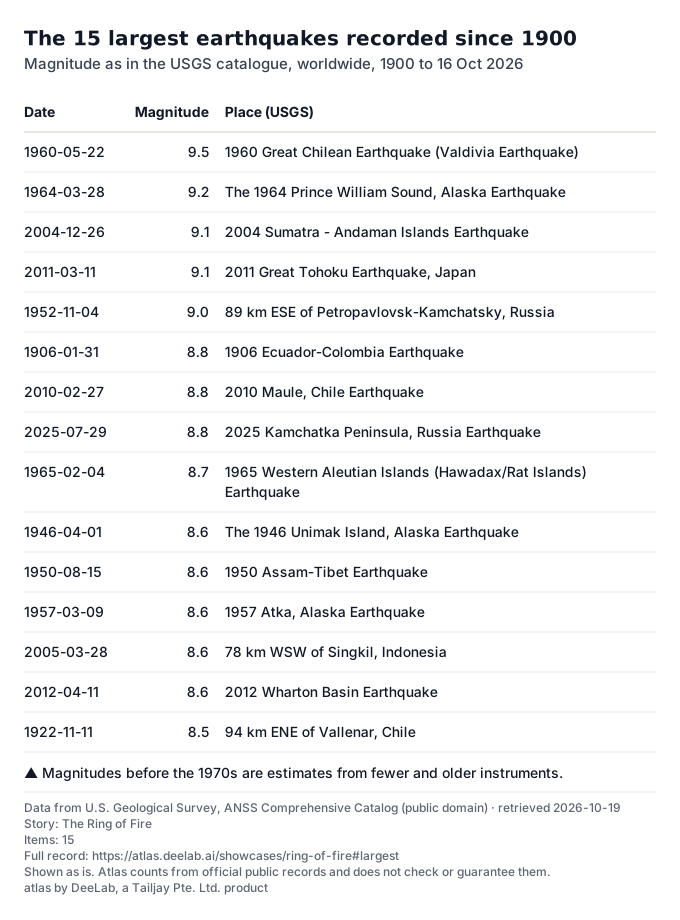
The largest earthquake in the USGS catalogue since 1900 was magnitude 9.5, 1960 Great Chilean Earthquake (Valdivia Earthquake), on 22 May 1960 (1st of 14,467 earthquakes of magnitude 6 or more).
6 of the 15 largest happened in 2000 or later, the latest magnitude 8.8, 2025 Kamchatka Peninsula, Russia Earthquake (29 Jul 2025).

Show the table (15 rows)
| Date | Magnitude | Place (USGS) |
|---|---|---|
| 1960-05-22 | 9.5 | 1960 Great Chilean Earthquake (Valdivia Earthquake) |
| 1964-03-28 | 9.2 | The 1964 Prince William Sound, Alaska Earthquake |
| 2004-12-26 | 9.1 | 2004 Sumatra - Andaman Islands Earthquake |
| 2011-03-11 | 9.1 | 2011 Great Tohoku Earthquake, Japan |
| 1952-11-04 | 9.0 | 89 km ESE of Petropavlovsk-Kamchatsky, Russia |
| 1906-01-31 | 8.8 | 1906 Ecuador-Colombia Earthquake |
| 2010-02-27 | 8.8 | 2010 Maule, Chile Earthquake |
| 2025-07-29 | 8.8 | 2025 Kamchatka Peninsula, Russia Earthquake |
| 1965-02-04 | 8.7 | 1965 Western Aleutian Islands (Hawadax/Rat Islands) Earthquake |
| 1946-04-01 | 8.6 | The 1946 Unimak Island, Alaska Earthquake |
| 1950-08-15 | 8.6 | 1950 Assam-Tibet Earthquake |
| 1957-03-09 | 8.6 | 1957 Atka, Alaska Earthquake |
| 2005-03-28 | 8.6 | 78 km WSW of Singkil, Indonesia |
| 2012-04-11 | 8.6 | 2012 Wharton Basin Earthquake |
| 1922-11-11 | 8.5 | 94 km ENE of Vallenar, Chile |
About this data
- Where it comes from
- U.S. Geological Survey: U.S. Geological Survey, ANSS Comprehensive Catalog (ComCat) · source
- Licence
- Data from U.S. Geological Survey, ANSS Comprehensive Catalog (public domain) (US public domain)
- Retrieved
- 19 Oct 2026, 02:36 UTC; the owner last changed the file on 19 Oct 2026
- What Atlas did
- Sorted every earthquake of magnitude 6 or more since 1900 by magnitude, largest first; equal magnitudes by date.
- Weak points
- Magnitudes before the 1970s are estimates from fewer and older instruments.
Shown as is. Atlas counts from official public records and does not check or guarantee them.
Step 4: How it changed
Significant volcanic eruptions
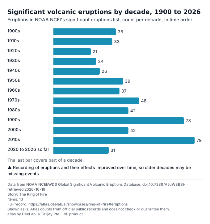
NOAA NCEI lists 530 significant eruptions since 1900. The decade with the most was the 2010s with 79 (1st of 13 decades, the last one not over).
An eruption is in the list when NCEI counts it as significant, for example one with deaths or damage, or a very large one; it is not a list of every eruption.

Show the table (13 rows)
| Decade | Significant eruptions (count) |
|---|---|
| 1900s | 35 |
| 1910s | 33 |
| 1920s | 21 |
| 1930s | 24 |
| 1940s | 26 |
| 1950s | 39 |
| 1960s | 37 |
| 1970s | 48 |
| 1980s | 42 |
| 1990s | 73 |
| 2000s | 42 |
| 2010s | 79 |
| 2020 to 2026 so far | 31 |
About this data
- Where it comes from
- NOAA National Centers for Environmental Information: NOAA NCEI/WDS Global Significant Volcanic Eruptions Database · source
- Licence
- Data from NOAA NCEI/WDS Global Significant Volcanic Eruptions Database, doi:10.7289/V5JW8BSH (US government work, public domain; cite the DOI)
- Retrieved
- 19 Oct 2026, 02:36 UTC
- What Atlas did
- Counted the eruptions in NCEI's Significant Volcanic Eruptions Database by start year, per decade, from 1900.
- Weak points
- Recording of eruptions and their effects improved over time, so older decades may be missing events.
Shown as is. Atlas counts from official public records and does not check or guarantee them.
Step 5: What is expected
What to expect in a typical year
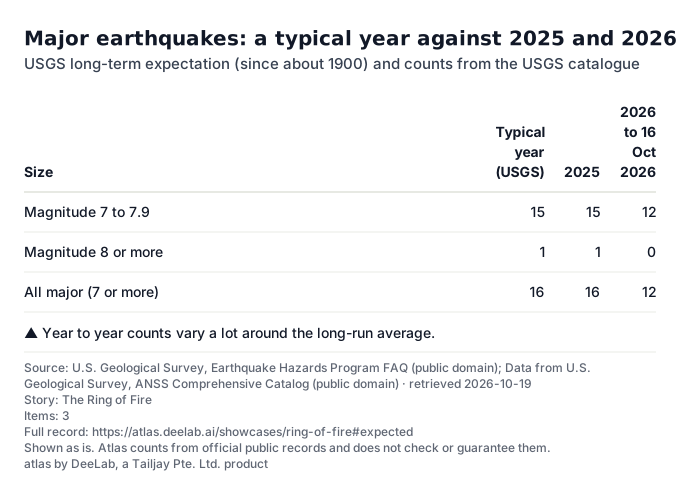
USGS says that, from long-term records since about 1900, about 16 major earthquakes happen in a typical year: 15 of magnitude 7 to 7.9 and 1 of magnitude 8 or more.
2025 had 16 earthquakes of magnitude 7 or more; 2026 had 12 to 16 Oct 2026.
This is a long-run average, not a forecast. Nobody can say when or where the next large earthquake will happen.

Show the table (3 rows)
| Size | Typical year (USGS) | 2025 | 2026 to 16 Oct 2026 |
|---|---|---|---|
| Magnitude 7 to 7.9 | 15 | 15 | 12 |
| Magnitude 8 or more | 1 | 1 | 0 |
| All major (7 or more) | 16 | 16 | 12 |
About this data
- Where it comes from
- Licence
- Source: U.S. Geological Survey, Earthquake Hazards Program FAQ (public domain) (US public domain)
- Data from U.S. Geological Survey, ANSS Comprehensive Catalog (public domain) (US public domain)
- Retrieved
- 19 Oct 2026, 02:36 UTC; the owner last changed the file on 19 Oct 2026
- 19 Oct 2026, 02:36 UTC; the owner last changed the file on 19 Oct 2026
- What Atlas did
- Quoted USGS's long-term rate from its Earthquake Hazards Program page; counted the same sizes in the catalogue.
- Weak points
- Year to year counts vary a lot around the long-run average.
Shown as is. Atlas counts from official public records and does not check or guarantee them.
Sources
- U.S. Geological Survey, ANSS Comprehensive Catalog (ComCat) · US public domain · retrieved 2026-10-19
- NOAA NCEI/WDS Volcano Locations Database · US government work, public domain · retrieved 2026-10-19
- NOAA NCEI/WDS Global Significant Volcanic Eruptions Database · US government work, public domain; cite the DOI · retrieved 2026-10-19
- PB2002 plate boundaries (Bird 2003), GeoJSON by Hugo Ahlenius, Nordpil · ODC-By 1.0 (conversion); both credits always (GL-5, D-044) · retrieved 2026-10-19
- USGS FAQ: long-term number of major earthquakes a year · US public domain · retrieved 2026-10-19
- Borders and coastlines: Natural Earth, 1:110 million scale, version 5.1.2, downloaded on 2026-10-18. Made with Natural Earth (public domain). Projection: Equal Earth. Borders follow Natural Earth's default view and are not a statement by Atlas.
Data to 16 Oct 2026. Atlas made no forecasts on this page; outlooks and long-run rates are the owners' own, with their dates.
atlas by DeeLab, a Tailjay Pte. Ltd. product